History of the Golden Circle: From Historic Sites to Modern Tourism
")
By Attila Balatoni
Local Travel Expert
Last updated: September 5, 2025
Intro

Today the Golden Circle is Iceland’s most popular sightseeing route, but its development as a tourism route is relatively recent. The route connects three historically and geographically important sites: Þingvellir National Park, the Geysir geothermal area, and Gullfoss waterfall.
Although the landscapes themselves have shaped Iceland for thousands of years, the idea of the Golden Circle as a travel route is relatively recent. The route gradually developed during the late 20th century as Iceland began to recognize tourism as an important part of its economy.
The history of the Golden Circle shows not only how the route became Iceland’s most popular day trip from Reykjavík but also how these landmarks helped shape the country’s cultural and national identity. Today, more than a million travelers visit the Golden Circle each year.
Overview: Golden Circle History
| Development of the route: 1970s |
| Name “Golden Circle” introduced: 1990s |
| Historic road section: Konungsvegur (King’s Road), built in 1907 |
| Main attractions: Þingvellir – Geysir – Gullfoss |
| Today: Most visited travel landmarks in Iceland |

From Historic Road to Famous Travel Route
The concept of linking Iceland’s most famous natural attractions into one travel route began to emerge during the 1970s, when improved road infrastructure made it easier for visitors to travel outside Reykjavík.
Þingvellir, Geysir, and Gullfoss were already well known within Iceland and had begun attracting international visitors. Connecting these sites into a single circular route allowed travelers to experience several of Iceland’s most dramatic landscapes within a single day.
Interestingly, the route itself remained unnamed for many years. The term “Golden Circle” did not appear until the 1990s, when tourism marketers began promoting the route internationally. The name is widely believed to reference Gullfoss waterfall, whose name translates to “Golden Falls.”
Today the Golden Circle covers roughly 300 kilometers (186 miles) when driven as a full loop from Reykjavík.
Konungsvegur: The King’s Road of 1907
Part of the modern Golden Circle follows a historic road known as Konungsvegur, or the King’s Road. This road was built in 1907 for the visit of King Frederick VIII of Denmark, who traveled to Iceland while the country was still under Danish rule.
At the time, the construction of the road symbolized progress and national pride. It connected important locations in southern Iceland and made travel between them easier than ever before.
Decades later, sections of this historic route would become part of what is now known as the Golden Circle.
Þingvellir: Where Iceland’s History Began
The first major stop on the Golden Circle is Þingvellir National Park, one of Iceland’s most historically important locations.
In 930 AD, the establishment of Iceland’s national parliament, Alþingi, took place here. Chieftains and farmers from across the country gathered each summer to settle disputes, trade goods, and establish laws. This open-air assembly continued for centuries and played a central role in shaping Icelandic society.

Þingvellir was chosen carefully. Its location in southwest Iceland made it accessible from many regions of the island. The cliffs of Almannagjá Gorge formed a natural amphitheater, allowing speakers to address large crowds gathered in the valley below.
Today, Þingvellir is both a UNESCO World Heritage Site and one of the most important symbols of Icelandic history.
A Geological Wonder
Þingvellir is also remarkable for its geology. The park sits directly on the Mid-Atlantic Ridge, where the North American and Eurasian tectonic plates slowly drift apart at a rate of roughly 2 centimeters per year.
This movement has created the dramatic rift valley visible today, making Þingvellir one of the few places in the world where visitors can walk between two continents.
Nearby lies Þingvallavatn, Iceland’s largest natural lake, covering about 84 square kilometers (32 square miles).
Geysir: The Original Geyser
The word “geyser” used around the world actually comes from the Icelandic verb “geysa,” meaning “to gush.” The original Great Geysir was once famous for enormous eruptions that could send boiling water up to 70 meters (230 feet) into the air.
Continuing east along the Golden Circle leads to the Geysir geothermal area in the Haukadalur valley.
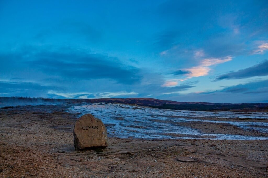
However, its activity gradually declined during the 20th century. In the mid-1900s, locals even used soap to trigger eruptions for visitors, but environmental concerns eventually halted the practice.
Today, Geysir is mostly dormant. Fortunately, its neighbor Strokkur remains highly active, erupting every 5–10 minutes and sending water 15–20 meters into the air.
Gullfoss: Waterfall That Was Almost Lost
The final stop on the Golden Circle is Gullfoss waterfall, one of Iceland’s most well-known natural landmarks.
Gullfoss lies on the Hvítá River, where the water plunges in two stages into a dramatic canyon. The first drop measures about 11 meters, followed by a second drop of 21 meters, creating a total fall of approximately 32 meters.
At the beginning of the 20th century, the waterfall almost disappeared forever.
In 1907, English investor Samuel Howell sought to build a hydroelectric power plant at Gullfoss. The land belonged to farmer Tómas Tómasson, who initially refused to sell it, famously declaring: “I will not sell my friend.”

However, he later leased the land, allowing Howell to pursue the project.
Today, the Golden Circle is more than just a convenient travel loop from Reykjavík. It reflects Iceland’s geological forces, cultural heritage, and historical identity.
Sigríður Tómasdóttir’s Fight to Save Gullfoss
Deeply attached to the waterfall, she fought tirelessly to prevent its destruction. She guided early visitors to the falls, helped build the first path to the canyon, and repeatedly traveled the long journey to Reykjavík to petition authorities.
According to local legend, she even threatened to throw herself into the waterfall if construction began.
Eventually, Howell abandoned the project in 1929 due to financial and logistical difficulties. In 1979, the Icelandic government declared Gullfoss and its surrounding canyon a protected nature reserve.
Today a small memorial near the waterfall honors Sigríður’s role in preserving one of Iceland’s most beloved natural landmarks.
The Golden History Timeline
| 930 AD – Alþingi parliament established at Þingvellir |
| 1907 – Konungsvegur (King’s Road) built for Danish king’s visit |
| 1907–1929 – Plans to build a hydroelectric dam at Gullfoss |
| 1970s – Golden Circle route developed for tourism |
| 1990s – “Golden Circle” name introduced in tourism marketing |
| Today – The route is Iceland’s most visited travel destination |
The Golden Circle Today
What began as a collection of natural sites connected by improving roads has become Iceland’s most famous sightseeing route.

The Golden Circle is more than just a convenient travel loop from Reykjavík. It is a journey through Iceland’s geological forces, cultural heritage, and historical identity.
From the ancient parliament at Þingvellir to the geothermal energy of Geysir and the powerful cascade of Gullfoss, the Golden Circle tells the story of Iceland itself, a land shaped by both nature and the people who have fought to protect it. Today, these historic locations are connected by one of Iceland’s most popular travel routes, allowing visitors to experience the country’s history, geology, and landscapes within a single day.
Sustainable Travel on the Golden Circle
Read More →Golden Circle FAQ
What is the Golden Circle in Iceland?
The Golden Circle is Iceland’s most known sightseeing route, connecting three major attractions: Þingvellir National Park, the Geysir geothermal area, and Gullfoss waterfall. The route forms a loop from Reykjavík and can usually be explored in a single day.
Why is it called the Golden Circle?
The name is widely believed to refer to Gullfoss waterfall, which translates to “Golden Falls.” The term “Golden Circle” became popular in the 1990s when Iceland’s tourism industry began promoting the route internationally.
How long has the Golden Circle been a tourist route?
Although the natural landmarks have been known for centuries, the Golden Circle route itself began to develop in the 1970s as road infrastructure improved and tourism in Iceland started to grow.
How long does it take to drive the Golden Circle?
Driving the full Golden Circle route takes about 3.5–4 hours without stops. Most travelers spend around 6–8 hours exploring the route with sightseeing stops along the way.
Can you visit the Golden Circle in one day?
Yes. The Golden Circle is one of the most popular day trips from Reykjavík and can comfortably be completed in a single day.
Can you drive the Golden Circle yourself?
Yes. The Golden Circle is one of the easiest self-drive routes in Iceland. The roads are paved and well maintained, making it accessible for most vehicles throughout the year.
What is the best time of year to visit the Golden Circle?
The Golden Circle can be visited year-round. Summer offers long daylight hours and easier driving conditions, while winter provides snowy landscapes and the possibility of seeing the Northern Lights.
Why is Þingvellir historically important?
Þingvellir is where Iceland’s national parliament, Alþingi, was established in the year 930 AD. It is one of the oldest parliamentary institutions in the world.
Who saved Gullfoss waterfall?
Sigríður Tómasdóttir helped protect Gullfoss in the early 20th century by fighting against plans to build a hydroelectric dam at the site. Today the waterfall is fully protected.